Delhi

After an overnight bus trip from Srinagar I am in unbearably hot Delhi again. I bought some tools which will enable me to fix the bike for the flight.
Well, I guess it's over. I am extremly pleased with this quick tour. In short time I've crossed a range of natural sceneries, from the north Indian planes, transition sub-tropic forrests, Alpine-like scenaries, baren high altitude mountains, dry Ladakh and dramatic Kashmir. The cultures changed accordingly, although it was too fast to notice all the nuances.
This trip was a substitute for a retry of Kashgar-Lhasa crossing, which I couldn't make this year. However all the adventures that I experienced, the climbs and descends that I made and fantastic scenery all along this journey satisfied me enough that I don't consider the return trip to Tibet necessary any more.
For those (like me) who find cycling data useful, here they are: 15 cycling days, 1 rest day; averages per cycling day: 110 km, 7h 9min, 15.7 km/h, 1035m of climbing.
Some more information about this and other rides are
here.
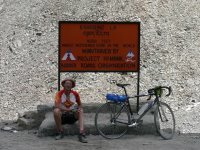
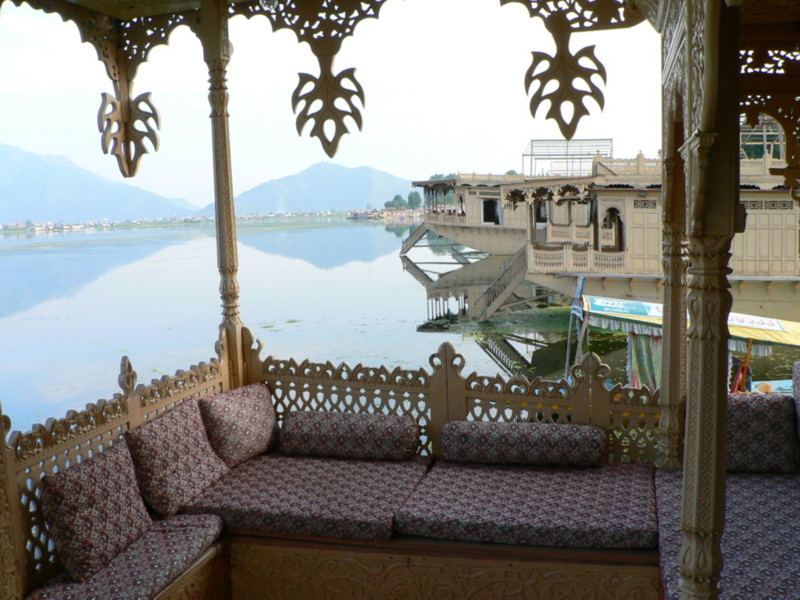
Srinagar

Sonamarg to Srinagar is a fast drop where you have little time to look around.
For me it was too fast, as somewhere in between I lost my tent and all of the tools. It probably happend on one of those speed-breakers which I saw too late and had barely managed to control the bike and not to spread over the road. Fortunately again, it was my last day of cycling and I accknowledged the loss only at the end of the day, when I took off my stuff to the
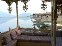
houseboat on Naghin lake. These houseboat are fabulous. I was treated like a king - I even had my own servant.
Pitty I couldn't stay a day longer.
Day 17: 78 km, 3h 8min. Total 1648 km.
Sonamarg
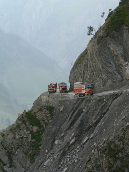
I've cycled over a number of passes these few weeks, but if I will remember one, then it will be Zoji La. It stands between Alpine-like valleys near Sonamarg and more rugged mountain ranges of upper Kashmir. The road is cut into a steep mountain slope and it seems it's a one-way road. I don't know how the police controls the current direction of traffic, but the fact is that the only time my passport has been checked by the police on a Leh-Srinagar stretch was just before the pass, on the north side. As a cyclist I was allowed to go in the wrong dirrection.

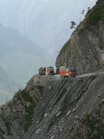
Before that, going up to the summit, I had a sur-realistic encounted with incredible number of trucks (at least 200) that were descending the pass practicaly bumper-to-bumber. With dirt road and the headwind it ment cycling in constant dust and exhaust fumes. By the time all the trucks passed I was as white as a baker after a night's shift. On the Zoji La more trucks were parked on a narrow road in a precipitous seting and were waiting a secret sign to move on. South side of Zoji La ends in smooth asphalt on which you practically fall to the village of Sonamarg.
Day 16: 120 km, 7h 38min. Total 1570 km.
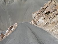
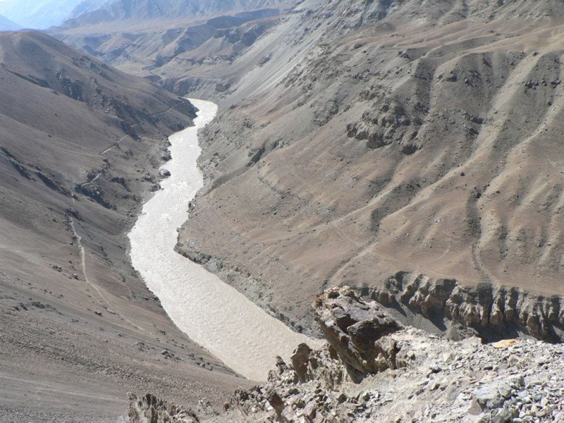
Leh - Kargil

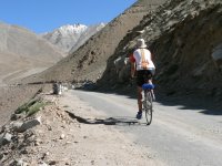
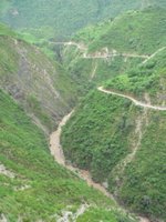
For anyone who likes desert scenaries, baren mountains, canyons, powerfull rivers and moonlike landscape, Leh-Kargil road is a must; forget the Manali-Leh!
I left Leh yesterday at 7:00. Dowhill to the river, then a bit up and a massive descent to the Indus which I had a pleasure of following most of the day. Then left turn along a smaller river valley until Lamayuru gompa road forks to the left and I turn right up into the climb.
And what a climb! There are small tight switchbacks at the start then longer h

air
pins all the way up the mountain side. I watched for the road above me and couldn't find a trace of it, yet it was there and from above the dramatic unbelievable view of what you have acomplished. There was something strange: smooth, ippecable asphalt, yet there wasn't a truck or a car for the whole 15 km up. I was late at the top, 19:00, as I was stopping frequently to enjoy this fantastic lanscape. It was evening on the downhill ride and around 19:30 I found an abandoned building and slept on its terrace, with a look on Lamayuru gompa (?).
The next day I found out that I probably missed the main road to Lamayuru and took a side one. I whish for more side roads like that. That explains why there were no traffic.
The next day continued with a Fatu La pass and Namika La. I may be repeating myself - but these are excellent climbs and fast thrilling winding descends on good roads. Only about 20 km before Kargil t
here were some roadworks whereI had to cross sections with ankle-deep white dust. This goes dirrectly into the chain and makes a mess of it.
I repeat - fantastic portion of the trip!
Day 15: 103 km, 6h 8min. Total 1450 km.
Day 14: 131 km, 8h 1min. Total 1347 km.
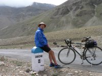
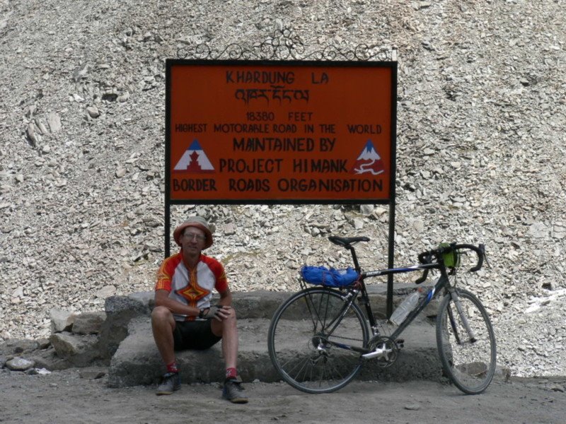
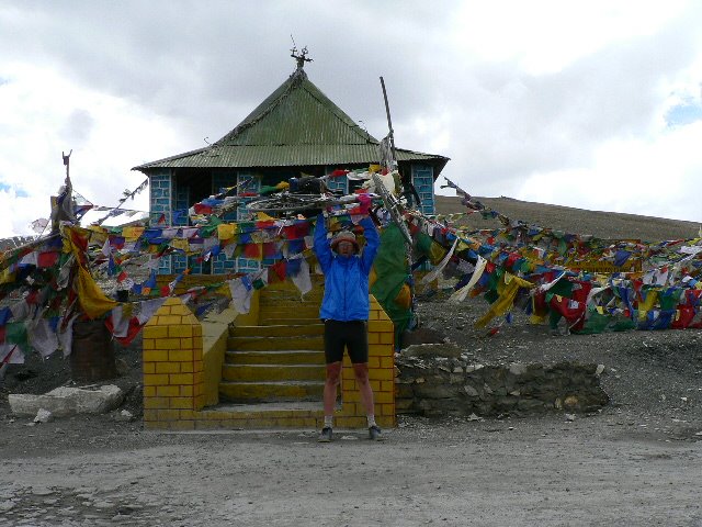
Khardung La
I just came from Khardung La. Whoooh, what a ride! I was thinking of missing this pass altogether, because it would take me two days (1 for the permit, 1 for the ride), would relieve me from some cash, and I didn't particulary like the "must-do" cling about it.
But, I'm glad I made it. The pass (39 km, 1800 m, 4.5% average) is well laid out, and gives you the view of what you've made and what lies ahead. It was rather easy though, I made it in 30/22, leaving two lowest gears for some emergency, which never came. The previous passess I gruelled in 30/26 and a cadence below 60. Well there's no secret to it: I made it without most of the luggage - I left 4 redudant kgs at my guesthouse. If ever anyone says weight doesn't matter! It made a world of difference.
As I came to the top there were some "cyclists" pulling their bikes off the rack of a van, posing before the Khadung La sing and then dropping downhill to Leh. I was really angry about it, it made all my effort look ridiculous. Going downhill I met another van with bikes on top. I couldn't help myself and gave them a finger (pointing down). I know they can do whatever they want, but, ...
The downhill was, as usual, 2-fold. First 10 km of rocks and dirt, then a smoothest asphalt I've came across in India. This is how it should always be! And if I won't find it in Asia or elswere, then good-buy third world, I'm going to cycle in France.
A-propos, I met two french cyclists on the way up. We chatted a bit and a question of Alpe D'Huez vs. Khardung La came up. I was of the oppinion that Alpe d'Huez is tougher (never being there, but it's about 10 km of 10%), they thought the opposite.
What do you think (especialy those that made both)?
Day 13: 77 km, 6h 6min. Total: 1216.
Day 12: 0 km, 0h 0min. Total: 1139.
Leh

I came to Leh today after a fantastic 30 km of coasting, following the valley of unknown river, then reaching Indus near Upshi, some pleasant flat ride and final 8 km uphill to Leh. I applied for an Iner line permit to cycle up the Khardung La - supposedly the highest motorable pass in the world - which I will get tomorow afternoon, so two more days in Leh, I guess. Well I could use some rest, I feel my mucles are blocking.
Day 11: 78 km, 4h 8 min. Total 1139 km.
Tanglang La

I woke up and found the rear tyre is flat. What the hell!!? There was nothing wrong with it yesterday. I changed the tyre and started suspecting that was a sabotage. There was an invisible slow leak on the outer side of the tube and I couldn't find anything in or out of the tyre on the same spot - a typical signs of a needle pinch. That was a not good start for the highest pass, but I didn't let it bother me. I had some slight altitude sickness symptoms, but I'm an old cat now, so I moved on. There is quick climb right after Pang and then a long ride across the high plateau, very much Aksai Chin like, which goes on and on, firstly on packed dirt then on asphalt and by the time you looked around you are already climbing the Taglang La. The top of the pass is visible from afar, at least from 20 km, it's high and far in the distance, to give you a thourough test of your nerves. I was at the top (~5100m) a bit earlier then yesterday. After few mud and stone streches, as is the case near the top of all passes, I enyojed again a huricane downride, stopping only to articulate my fingers. Just before Rumtze I spotted a nice place to camp, and after consulting few shepards I decided to give my tent a test - otherwise I would be carrying it for nothing.
Day 10: 97 km, 7h 39 min. Total 1061 km.
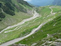
Lachalung La
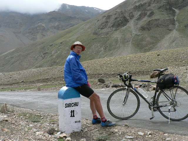
The first part of the ride was a comfortable rolling over the plains up to Sarchu. Then there are 21 Gata loops and for some reason they stopped counting after 21, as the road climbs on and on before it drops down to some river and climbs the final ~20 km to the difficult Lachalung La - stated as being above 5000m, but my altimeter doesn't show it. I was a bit earlier this time at the top and so had a good chance of enjoying the ride down the spectacular canyon and gorges of Pang (?) river. 1 km before Pang there were some tents where I chose to stay overnight.
Day 9: 101 km, 7h 50 min. Total 964 km.
Baralacha La
The second pass, Baralacha La, goes through baren landscape, and although difficult, I will not remember it much, except that there was a road block due to roadworks that only cyclists could pass - which means me. I was at 18:00 at the top, and it was accordingly cold, so I was happy to run into a tourist tent just couple of kilometeres below. I had wet feet from some fordings and a big pile of blankets that was put on top of me during the night didn't feel too unconfortable. In the middle of the night I was awaken by a feeling of cold water dripping town my neck. I reach for it and got a brief hold of a cold wheezly creature - probably a gecco trying to crawl down my collar.
Day 8: 110 km, 9h 33min. Total 863.
Rohtang La
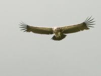
I wonder if one can get emotional about a pass? Because it was just what I felt, cycling the last meters toward the Rothang La. It is a long climb from Manali, 51km and almost 2000m of altitude difference. You cross various climate ragions, from the deciduous to coniferous forest, high grassland and baren ground on top. What is interesting is that most of the time you can look back and track your progress - much of the road is vissible from your standpoint. Soaring vultures are part of the joy climbing it. I think it was on India's independence day, so a big number of Indian tourists, drivivg to the pass from as far as Chandigarh, was not surprising. I had good weather up to the top when the clouds closed, and on the downhill side I stoped few times
for a chai to warm my fingers. Down in the valley a felt a conspicious softness in back wheel - yes, a flat tyre. It was a slow leak, so with a bit of re-pumping I managed to make it to Sissu when it started raining and I started a seach for a room.
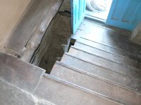
But, the day and its adventures were not over yet. After a shower I changed and patched the tube and I felt a nice dinner in a nearby hotel would make a perfect ending of the day. I went out of the room to the dark corridor while a boy came to open the outside door. I stepped toward the stairs and - fell through! There was nothing below my feet and if I didn't brace myself against the stairs at the last moment, I'd be in the basement with possibly a couple of bones boken. Luckily I got away only with a scratch on my back side and trousers, but I lost all of the appetite.
Day 7: 86 km, 7h 26 min. Total 753 km.
I am in Manali.

After 5 days of cycling I am at the start: of the Manali-Leh road. There has been a lot of climbing, but most of all it was hot. Not so much down in the plane, but up here, at the altitude around 1500m the temperature still reaches 35 c. I hope it's over now.
How was it today? Well, to Aut it was mostly down and a quick ride. There's a 3 km tunnel before that town. Then it again goes up and down and up with increasing traffic as I approached Manali. Tourists, I guess.
Day 6: 130 km, 7h 52 min. Total 667 km.
Rejoining #21 - a hard day
From Tattapani a long 25 km climb starts with 1000m difference. The scenery is spectacular, with looks on green mountains with rice terraces and river valley deep down. It was a true Jalori for me, and I wanted to make a picture at the top, but there was an uninspiring little shop with uninterested owners, so after a soft drink I moved on. The roads goes in a roller-coaster fashion up and down with a difficult climb or two and the final 30 km descent of 1000m all the way to the road #21, at Sundal Nadur, 24 km before Mandi.
I don't know if I should recommend this "shortcut" from Simla to Manali. The scenery is truly stunning and there's so little traffic that you can't believe you're in India, but the surface is not so good and there's more than 2000m of climbing.
Day 5: 115 km, 8h 23min. Total 537.
What a day!

The third day is always the best. There were two climbs this day: from 1100m to 1800m, drop to 1400m and up until Simla at 2100 m. I called home from Simla and then headed towards Jalori La. A motorists greets me and I ask him about the climb to Jalori. He says the pass is closed due to landslide and shows me another option: the road that turns left just 4 km from Simla and goes through Naldera, Tattapani, Rohanda, Chal Chowk and merges to road #21 just before Mandi. He finally persuades me saying this road is virtually without traffic, but still paved. I copy the names and distances from his map (I don't have one as you know) and off I go. There's a 40 km downhill for a start, from 2100m down to Sutlej river and Tattapani at 770 m, where I slept. Excellent scenery, firstly through the woods, then the view opens on green mountain slopes and Sutlej river. The traffic is truly almost non-existent but the road is not in perfect condition - it is paved, but with holes and patches.

Day 4: 132 km, 8h 0 min. Total 422 km.
A half day of rest

I didn't sleep much last night, the mosquitoes were all over me. I also changed the plan instead of going on the road #21, I went towards Shimla. Not an interesting day. The road to Chandigarh is still flat, after Pinjore it starts to climb steadily. I was quite sleepy, so at 14:00 I decided to call it a day and checked at a hotel. The plan was to take an afternoon nap before the mosquito hordes move in.
Day 3: 74 km, 4h 23 min. Total 290 km.
Early start in Delhi
It was 5 am when I rolled off from the Delhi airport. It was night still. After half an hour it started raining, really hard, monsoon rain. I was at the edge of panicking: cycling in the night without lights, in the downpour, on unfamiliar side of the street, on an Indian highway. The true hell lasted a quarter of an hour, then with the first light the rained lessened and vehicles revealed their familiar form, not just being two vicious lights trying to run over me.
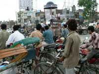
The first part was a search out of Delhi to Grand Trunk road - a bad part. The second part was racing on a left lane of the G.T.road, trying to make as much reserve in distance as possible. There was a third part too - going through the traffic chaos in the towns in between - I didn't know if I should laugh, cry, or shout like a madman.
Anyhow, I came to Ambala around 18:00.
Day 2: 215 km, 9h 49 min. Total 215 km.
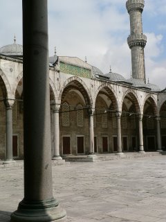
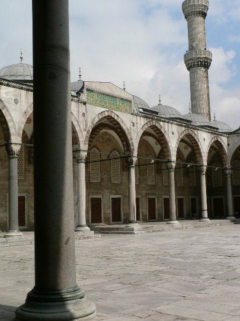
Hanging in Istanbul
Between flights I had a day to spent in Istanbul - perfect acclimatization from Europe to India, so I thought. My bicycle was checked directly to Delhi, so now worries with it. At the airport I got a Turkish visa, in less then a minute:
The Lady at the counter: "Yes, please."
Me: "Visa."
Lady: "15 euros."
Me: give the money.
Lady: gives the visa.
Off to the town with metro, found a nice hotel, had a good night sleep, next day checked Blue mosque and Hagia Sofia and it was time for a flight to Delhi.
Day 1: No cycling today. Still, a nice day.
On the road again !

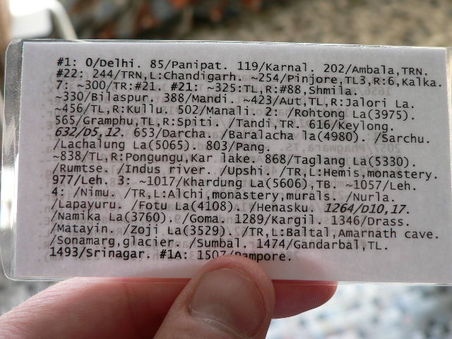
I'm starting this year's cycling tour on Sunday - heading for India instead of Tibet, but still staying faithful to the Himalaya region. To be more precise, here's the first part of my itinerary. That's my map in fact - as a dedicated ultra-light cyclist I am leaving the real map at home.


